National wetlands inventories are developed to map the extent and characteristics of wetlands as country level database. GIS-based Pakistan Wetlands Inventory (PWI) being developed under the Pakistan Wetlands Programme, aims to promote the sustainable conservation of freshwater and marine wetlands and associated important biodiversity.
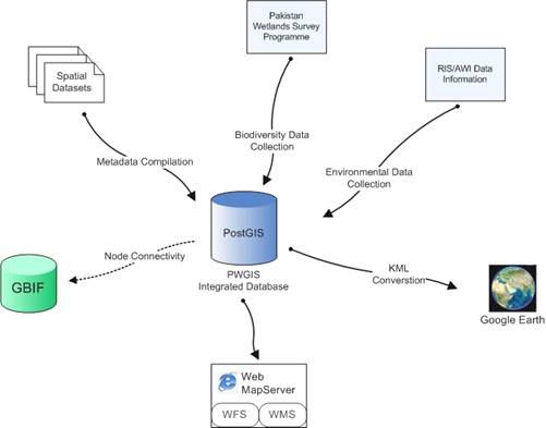
All of the Pakistan Wetlands Programme activities are covered in its 10 Outputs. Output 2 is composed of long-term wetlands survey programme and wetlands GIS. The overall goal of PWGIS Integrated Database Design is to provide a mechanism to assimilate information being produced through wetlands surveys and wetlands GIS development process.
 Taking into account the Programme structure and inventory needs three main components, environmental characteristics of the Wetlands, time-series biological survey observations collected through field surveys and spatial datasets related to wetlands generated through massive GIS data building activity were identified(Qamer, 2007). Standardised data models for these three components, were studied respectively A Manual for Asian Wetlands Inventory, Observational Data Standards by Taxonomic Database Working Group and Geograpic Information – Metadata ISO 19115 (Finlayson et al, 2002; TDWG, 2006; ISO, 2002;). In addition, Ramsar Information Sheet (RIS) was thoroughly studies to accommodate all socio-ecological parameters necessary for wetlands evaluation. A comprehensive database, PWI data model, was designed by modifying and integratingthem together to serve the specific needs of the inventory. Standard data encoding forms were also designed for eight thematic areas of survey programme which includes Birds, Mammals, Fish, Reptiles, Amphibians, Planktons, Vegetation and Water Quality.
PWI data model is implemented in OGC compliant open source software framework. Database Postgres with spatial extension PostGIS is used to tightly couple the spatial and non spatial entities of the inventory. This is similar to the infrastructure being used by GBIF for its global biodiversity portal. This compliance of biological and technological standards will enable connectivity of PWI with GBIF as observational data node.
A web-based application will be built on the top of the currently designed PWI data model. The envisaged application will be compatible to connect with global biodiversity portals like GBIF and visualization of PWI data records over the Google Earth.