
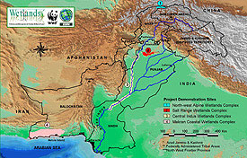
 Map of the Four Wetlands Complexes in Pakistan
 1- North-west Alpine Wetlands Complex
2- Salt Range Wetlands Complex
3- Central Indus Wetlands Complex
4- Makran Coastal Wetlands Complex
Click on the map for an enlarged view.
For more details on these Wetlands Complexes, please refer to the specific Programme Sites.
Source: GIS Lab. WWF - Pakistan
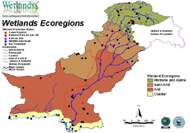 Wetlands Ecoregions Map
1- Mountain and Alpine Ecoregion
2- Semi-arid Ecoregion
3- Arid Ecoregion
4- Coastal Ecoregion
Click on the map for an enlarged view.
Source: GIS Lab. WWF - Pakistan
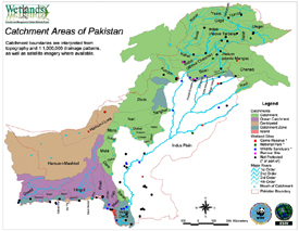 Map Showing Catchment Areas of Pakistan
The Catchment area boundaries have been interpreted from topography and 1:1,000,000 drainage patterns, as well as satellite imagery, where available.
Click on the map for an enlarged view.
Source: GIS Lab. WWF - Pakistan
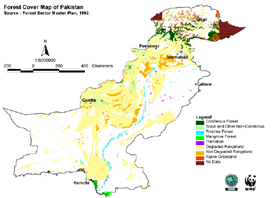
Source: Forest Sector Master Plan, 1992.
Click on the map for an enlarged view.
Source: GIS Lab. WWF - Pakistan